A race is on to see where the first "modern" roundabouts will appear in Alameda:
- Will it be at Clement Ave and Tilden Way (where the California Department of Toxic Substances Control finally signed off on remediation of the rail tracks next to Tilden Way, which had been slightly delaying that project)?
- Will it be along Central Ave/State Route 61 (which after 10+ years of planning — plus the massive bureaucracy of Caltrans and federal funding requirements — is expected to begin actual construction on January 27)?
- Will it be along one of the hypothetical Neighborhood Greenways?
- Or will it be at a newly revealed intersection in Bay Farm that's set to be repaved?
Civil and traffic engineers, I can already hear your protests: you will point out that this is muddling two completely different types of intersection treatments:
- Some of the items on this list represent full size "modern roundabouts."
- Whereas at least one of these projects represents "neighborhood traffic calming circles."
But to a civilian user these distinctions matter a lot less. These are all improvements that moderate the speeds of auto drivers, decrease "conflict points" where drivers can potentially t-bone each other, and improve the visibility of pedestrians and cyclists. These all involve cars goin' round a circle!
To a non-expert person who cares about the overall quality and safety of Alameda street network, what matters more than understanding fine-grained engineering distinctions are questions like: where are these roundabout thingies going to be installed around town? and when will they actually be ready?
Going slow: Thoroughly crafted Neighborhood Greenways
As part of the Neighborhood Greenways program, city staff and consultants have been exploring mini neighborhood traffic calming circles as one of a broader toolkit of "treatments."
As they've progressed through various public engagement and outreach efforts, the team shared multiple renderings of these hypothetical installations:
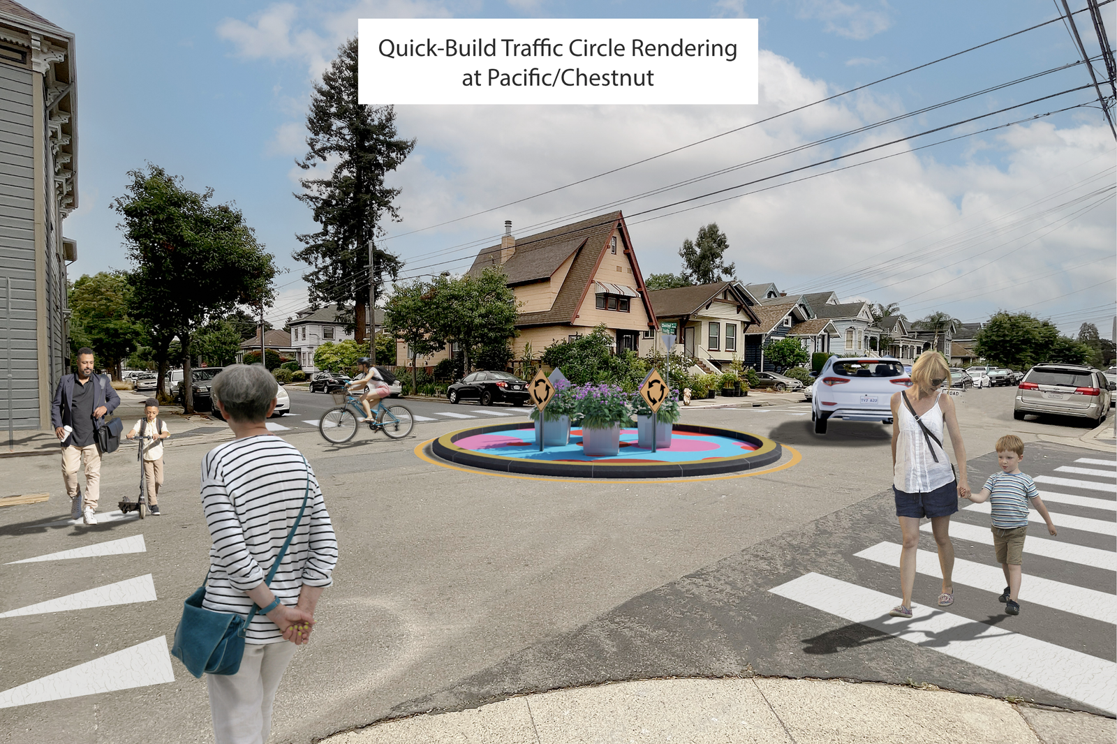
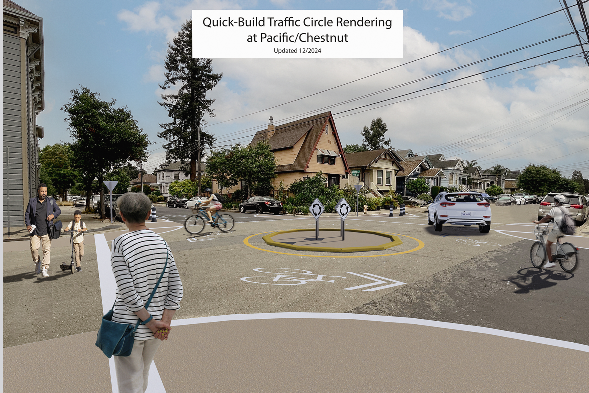
Left: initial rendering Right: revised rendering released Dec 10, 2024
When that second rendering was released, I started toggling back and forth between the two to try to notice what had changed — and the experience brought me back to a visit to Champaign/Urbana. I had applied to a range of schools, with the goal of studying how people navigate cities, and I was visiting with a cognitive psychologist, with the offer of admission to his department. His claim to fame: a video that distills how much of human attention works — or doesn't work. I won't ruin the experiment and reveal what happens during the video. (Suffice it to say, I didn't want to be a cognitive psychologist nor did I want to live in southern Illinois. But it turns out the professors in those Illinois labs were so much more friendly and supportive than the place I did eventually go... oh well!) Anyway, that concept of change blindness is what I was remembering while toggling back and forth between these two pics and trying to suss out:
- Is it meaningful that some of the fake people in the rendering changed? No.
- Is it meaningful that the paint and the planters have been removed? Maybe, but not really. They look nice, but maybe this is just a sign that the city doesn't want to budget for those improvements — instead unofficially letting neighbors paint and plant those spots.
- Is it meaningful that the stripes have changes? Maybe. (An overhead view explains more of what's going on with the paint stripes.)
- Is it meaningful that the material making up the circle itself has changed? Yes! That's probably a substantive change hidden amid everything else that just looks visually different. This material, its height, and its slope are critical aspects to how seriously motorists will take this entire installation. Does it look like an installation that's merely advisory — a minor bump that they may register as their car's wheels mount the boundary? Or is it serious enough in appearance and in form to have a behavioral impact and a physical impact?
But these are just guesses. The city has not finalized designs, nor have they finalized where these mini traffic circles may be installed. The Neighborhood Greenways program is an ongoing process.
Going fast: A modular roundabout in Bay Farm
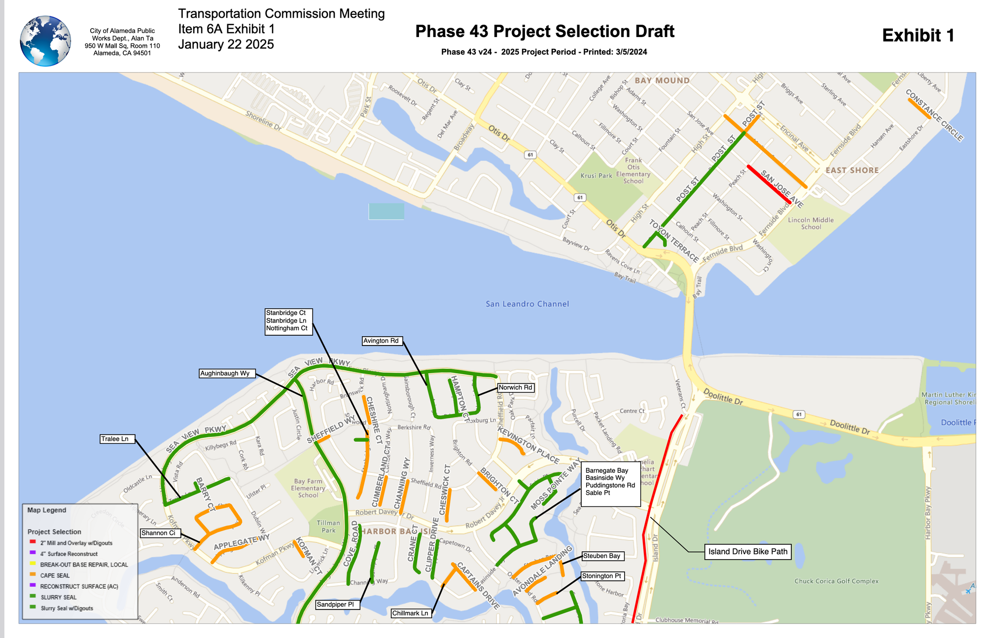
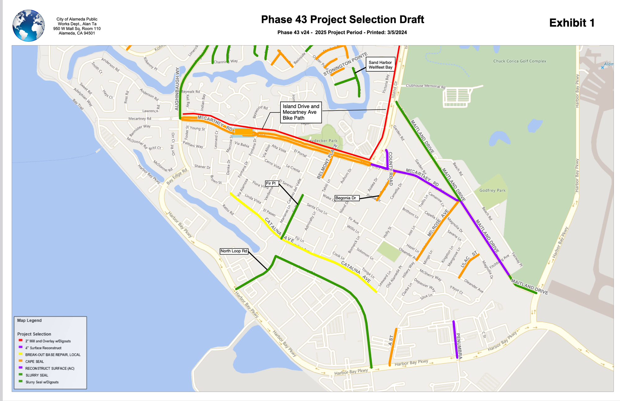
As part of this year's repaving around Bay Farm, city Public Works staff and their consultants are going to turn the oddly shaped intersection of Mecartney Road, Maitland Drive, and Melrose Ave into a roundabout:
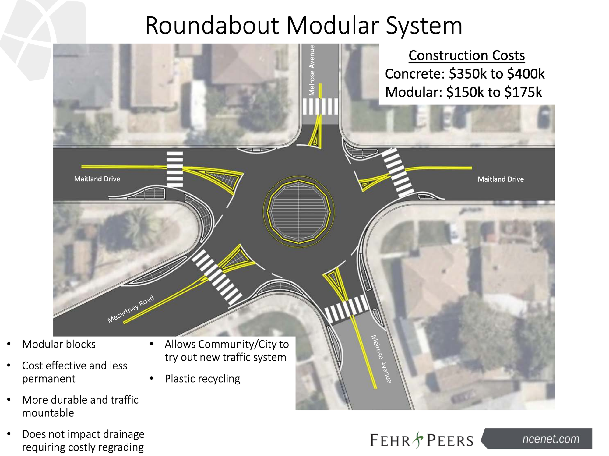
(Technically speaking this a "modern roundabout" given the way the curbs are slightly extended and the roadway curves to guide motorists into and out of the roundabout. This is not a "traffic circle." Then again, I am not a Professional Engineer™)
Two things are striking about this plan:
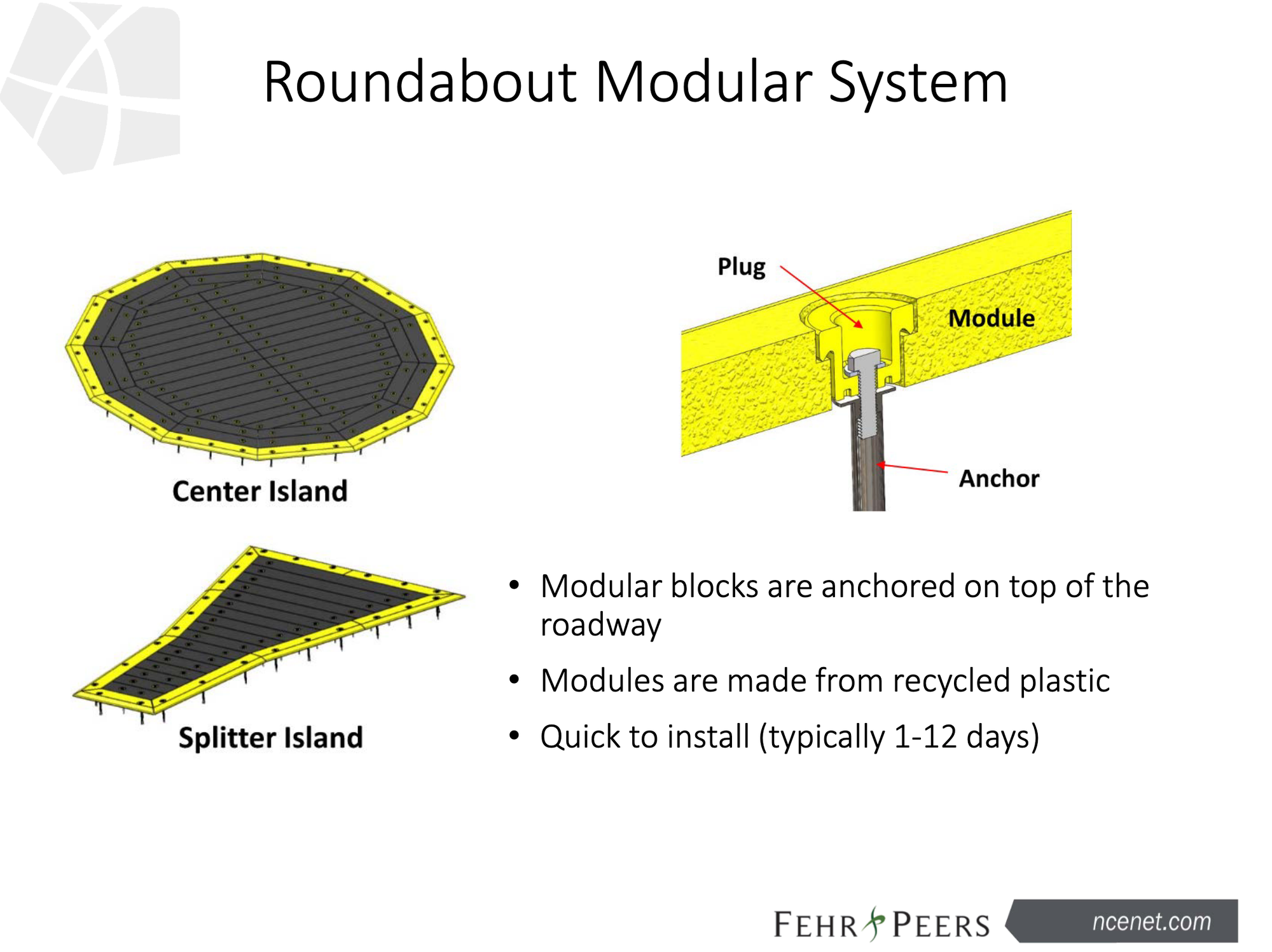
- The city is going to use pre-existing modular components. Their consultants have used the same components to build a similar modular roudabout in the San Francisco Presidio recently:
- The city shared this as an informational update to the public and the Transportation Commission. The engineers said that they currently have "65% designs" completed. They may use the questions and feedback collected to further refine as they complete the plans — but as far as public engagement goes, this public meeting of the Transportation Commission was the opportunity.
Having this one opportunity for public involvement in repaving projects is a great improvement to the city Public Works department's previous process. This blog previously argued in a post titled "Alameda and the three bears... of public engagement" that the city would benefit from a tad less public process for some projects (like the Neighborhood Greenways) and simultaneously a tad more public process for others (like repavings). For this year's re-paving projects across Bay Farm, the city:
- chose which streets to repave based on the current quality of their pavement, but then chose the designs for how to repave those key streets based on the adopted Active Transportation Plan (which was itself created from extensive public engagement)
- included in the plans the repaving of the bumpy shared use (walk bike) trails in Bay Farm alongside Island Drive and Mecartney Road
- in response to a public comment at this week's Transportation Commission meeting, recognized that the plans had left out repaving of the northern-most section of the Island Drive trail as it reaches Veterans Court — and staff said that they could adjust the plans to ensure that segment is also repaved
This feels like a Goldilocks "just right" level of public involvement: staff can leverage the multi-year engagement effort of the Active Transportation Plan; they now know they'll be presenting plans briefly but publicly, so they have an incentive to think ahead to public concerns; the general public and those of us on the Transportation Commission get to understand engineers' plans and weigh in with some questions and feedback; staff use their judgement to accommodate this feedback as it fits into the scope of the repaving projects; and the process moves on ahead toward implementation. (This repaving process is completed once per year, with each year having a focus region — next year's focus will be western Alameda Island.)
Experimenting across a portfolio of projects
Which of these approaches is better: the slow approach that aims to gradually build consensus around site-specific improvements? or the faster approach that's generic but efficient and repeatable across the city?
On balance, I think we should be asking our elected officials and city departmental leadership for some more of the "going fast" approach. We want and need real improvements to streets. Perfect plans and processes are useless when they're only on paper.
However, this city is also a complicated place. I've come to realize that I simply don't understand the city's strategy on the Neighborhood Greenways program. It must just be the way it is for... reasons.
So be it. If we can zoom out, it's reassuring to see the city now having multiple approaches operating in parallel — both to roundabout and traffic circle treatments in particular, and more broader to all forms of street safety improvements:
- major corridor redesigns like Tilden/Clement, Otis Drive, Central Ave, Encinal Ave, Lincoln Ave, etc (that will always require a larger amount of long-range planning, and sometimes involve political push-and-pull with Caltrans)
- the Neighborhood Greenways (née Slow Streets) network
- the city's annual paving maintenance program
- the Rapid Response after Fatal Crashes Program
- the completely different way in which the city handles the street network and related infrastructure at Alameda Point
For a blog like this, it's appealing to pick a singular solution and argue for it. But for a complicated organization, like the City of Alameda, a portfolio of assorted approaches may just be a reasonable reality.
It's still the case that each approach will have its strengths and its weaknesses. The city's leaders — particularly the electeds — aren't always upfront about acknowledging these tradeoffs. And this portfolio approach can blur priorities (it's easy to see progress overall, while ignoring the projects that are stuck and the specific spots around town that are being overlooked).
If tradeoffs and priorities are clearly articulated, the city's leaders can monitor the outcomes of these differing approaches. And us residents can also watch for which modern roundabouts and mini traffic circles and related improvements appear around Alameda first. As long as we're not all so busy that we fail to notice the gorillas in our midst.