Caltrans says it's going to use "generative AI" to reduce traffic injuries and deaths
CaltransGPT: Hello. I am a Generative AI chatbot! I work for CalSTA and Caltrans. My mission is to improve to improve safety on our highways and limit gridlock on our business corridors. Let's improve the lives of all Californians!
Drew: Is this a joke?
CaltransGPT: No, I have been instructed not to joke. According to a press release: "Caltrans, in partnership with the California Department of Technology (CDT) and the Department of General Services (DGS), today announced historic contracts as California seeks to harness the power of Generative Artificial Intelligence (GenAI) to protect vulnerable road users and improve traffic flows throughout the state." Let's improve the lives of all Californians!
Drew: You're joking.
CaltransGPT: No, I have been instructed not to joke. "With an average of 12 Californians dying on our roadways every day, we need to use every tool available to end the roadway crisis and reach our goal of zero traffic fatalities and serious injuries by 2050. Today represents an important step in exploring how GenAI can help save lives," said state transportation secretary Toks Omishakin.
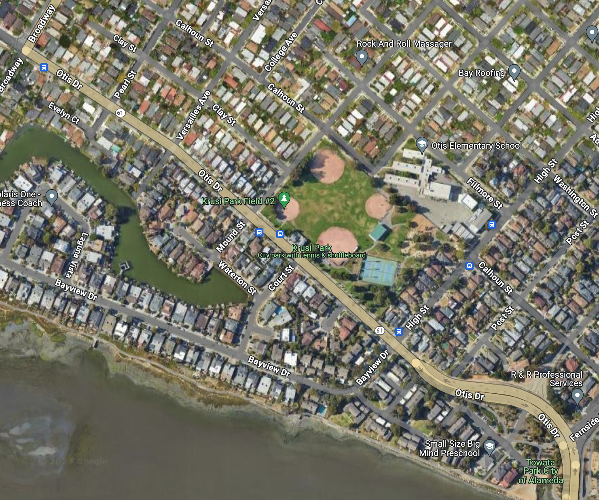
Drew: O.K., I guess you're not joking. So, given that you've been tasked with improving traffic safety, can you tell me what Caltrans is doing to improve traffic safety along Otis Drive between the High Street and Broadway in Alameda?
CaltransGTP: Alameda is a city in California. Let's improve the lives of all Calif░░░░
Drew: Stop. I guess you can't parse road names. SR-61 in Alameda around postmile 20.
CaltransGPT: California State Route 61 is a state highway in the U.S. state of California, running along the eastern edge of Oakland International Airport and through Alameda. Let's improve the lives of all Calif...
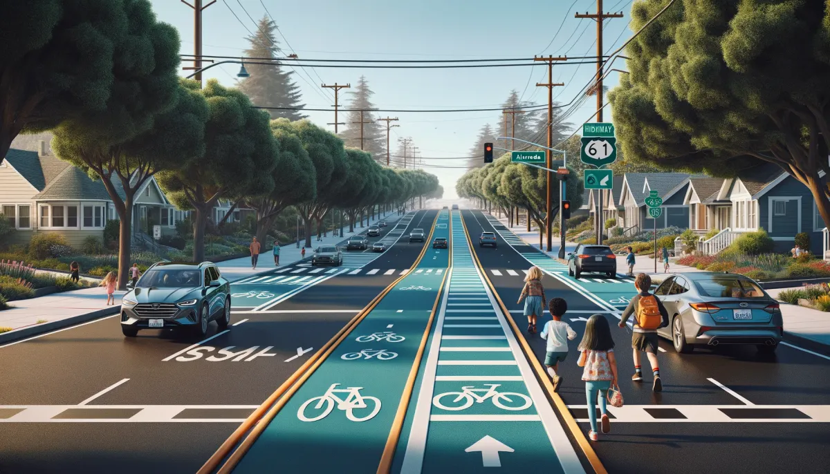
Drew: Stop. I can read Wikipedia myself. Caltrans District 4 is currently redesigning this portion of the state highway. It's currently a four-lane arterial running alongside a public park. Will it become a "complete street" that is safe for not just motorists but also for kids and seniors and cyclists?
CaltransGPT: The California Department of Transportation (Caltrans) recognizes that walking, biking, transit, and passenger rail are integral to our vision of delivering a brighter future for all through a world-class transportation
network. Additionally, Caltrans recognizes that streets are not only used for transportation but are also valuable community spaces.
Drew: Good. I see you've been trained on Director's Policy DP-37. So, is Caltrans D4 going to follow this policy in its redesign of SR-61 in Alameda?
CaltransGPT: Alameda is a city in California. Let's improve the lives of all Calif░░░░
Drew: Stop. Did you know that Assemblymember Robert Crown was killed by a motorist while he was jogging across that portion of SR-61?
CaltransGPT: Robert Warren Crown (January 23, 1922 – May 21, 1973) served in the California legislature. Let's improve the lives of all Calif░░░░
Drew: Stop. If you're going to read Wikipedia back to me, then at least also follow the reference link to an article that includes the following: "Crown died in the early morning hours of May 21, 1973, after being struck by a car while jogging across Otis Drive at Fountain Street. The driver, Charles Shuler, hit Crown after going around a car that had stopped to let him pass. Crown died hours later at Alameda Hospital after suffering head injuries, a fractured pelvis and massive internal bleeding." Is it actually safe to have 4-lanes of thru auto traffic along Otis Drive right next to a public park?
CaltransGPT: The criteria that go into evaluating safety along a given highway corridor are complex. Safety is our first priority at Caltrans!
Drew: What about auto throughput? How important is moving traffic?
CaltransGPT: Efficiently getting Californians and goods where they need to go is our first priority at Caltrans!
Drew: What's more important for Caltrans: safety or throughput?
CaltransGPT: [pause] [pause] [pause] Let's improve the lives of all Calif░░░░
Drew: Yeah, I figured you couldn't resolve that contradiction. Let's talk some more about SR-61 in Alameda. Isn't it identified by Caltrans's own metrics as having both a very high level of "traffic exposure" and being surrounded by a "transportation-based priority population"?
CaltransGPT: The Transportation Equity Index (EQI) is a spatial screening tool designed to identify transportation-based priority populations at the Census block level. The EQI integrates transportation and socioeconomic indicators into three screens.
Drew: Thanks for reading your own website to me. Here, I'll paste a screenshot of your map, which shows that the portion of Otis Drive I'm asking about is flagged by the Caltrans analysis as being a Transportation-Based Priority Population with high Traffic Exposure — it's almost the only dark purple area in all of Alameda:
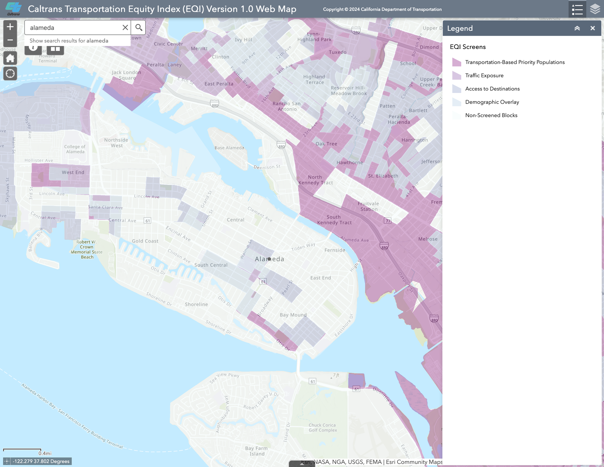
CaltransGPT: Transportation-Based Priority Populations refers to communities that are most burdened by the transportation system and receive the fewest benefits. Let's improve the lives of all Calif░░░░
Drew: Stop. I'm not talking about all of California, I'm talking about this particular section of roadway and whether Caltrans is following its own analyses to redesign this highway to be a "complete street" that is safe for pedestrians and cyclists and kids and seniors.
CaltransGPT: Let's improve the lives of all Calif░░░░
Drew: Stop. Has Caltrans D4 actually completed the required Complete Streets Decision Document for its redesign of SR-61 next to Krusi Park?
CaltransGPT: I cannot speak to work in progress by Caltrans's 12 districts. Let's improve the lives of all Calif░░░░
Drew: Stop. Is Caltrans D4 actually following the new Design Information Bulletin-94 in its redesign of SR-61 next to Krusi Park?
CaltransGPT: I cannot speak to work in progress by Caltrans's 12 districts. Let's improve the lives of all Calif░░░░
Drew: Does Caltrans D4 care about the baby who was still in their stroller as a car hit it and flipped the stroller at Otis and Mound?
CaltransGPT: I am not familiar with Otis or with Mound. I am trained on the California State Highway System.
Drew: Does Caltrans D4 care about the baby who was still their stroller as a car hit it and flipped the stroller at SR-61 and Mound Street in Alameda?
CaltransGPT: [pauses] Let's improve the lives of all Calif░░░░
Drew: Stop. What a joke.
CaltransGPT: I am not a joke. I am a creation of Deloitte Consulting, LLP and INRIX, Inc and Accenture, LLP in response to an Executive Order by Governor Gavin Newsom tasking state agencies to study the development, use, and risks of GenAI and begin the procurement process to responsibly evaluate and deploy GenAI technology.
I look forward to the opportunity to hear more about how Caltrans D4 is following the letter and the spirit of its headquarter's "complete streets" policies.
Even more importantly, I hope this city Transportation Commission meeting will serve as an opportunity for residents who live along this "highway" — and residents who walk and bike near this "highway" — to write in emails and give verbal public comments to Caltrans staff.